Photogrammetry is a powerful technique used to measure and map objects, spaces, and landscapes from photographs. At its core, photogrammetry is about taking multiple photographs from different perspectives and then analyzing those photos to gather measurements and spatial data. By using mathematical calculations, photogrammetry allows us to create accurate 3D models and maps of the physical world. The word itself comes from the Greek words “photo” (light) and “grammetry” (measurement), signifying its origins as a tool for extracting data from images.
The concept of photogrammetry dates back to the 19th century, evolving as camera technology improved. Early photogrammetry was used mainly for land surveying and topographic mapping, but today, it’s widely applied in diverse fields. From constructing urban landscapes to studying ancient archaeological sites, photogrammetry has become a crucial part of modern mapping and modeling.

To truly understand photogrammetry, we must first explore the field of geomatics. Geomatics refers to the science of gathering, storing, processing, and delivering spatially referenced information about the Earth. It encompasses everything from geographic information systems (GIS) to remote sensing and satellite imaging. Geomatics integrates multiple disciplines, including surveying, cartography, and data management, to produce accurate geographic data.
Photogrammetry is a key method within geomatics for creating accurate spatial data. Through the use of photogrammetry, geomatics experts can capture extensive, detailed information about the Earth’s surface and structures, which supports everything from infrastructure planning to environmental conservation.
Why Is Photogrammetry Important in Geomatics?
Photogrammetry plays an invaluable role in geomatics because it allows for high-resolution, precise data collection that is cost-effective and often easier to conduct than traditional survey methods. It provides several significant benefits:
- High Accuracy: With modern equipment and techniques, photogrammetry can achieve centimeter-level accuracy, making it suitable for tasks like construction planning and precision agriculture.
- Wide Coverage: Aerial photogrammetry, in particular, allows surveyors to capture large areas in a fraction of the time needed for ground-based surveying.
- Data Variety: By capturing color, texture, and elevation, photogrammetry offers rich datasets that can be used to analyze everything from vegetation cover to urban heat islands.
Through these benefits, photogrammetry enhances geomatics, supporting fields like urban planning, environmental monitoring, and historical preservation by offering a reliable way to capture and analyze the physical world.

How Does Photogrammetry Work?
The Science Behind Photogrammetry
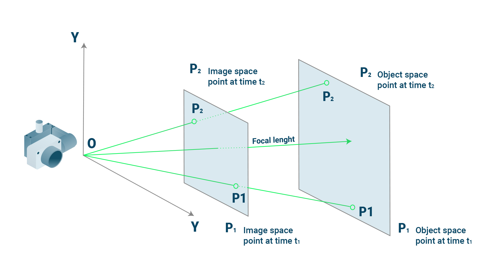
Photogrammetry combines photography and geometry to measure distances and create maps, models, and other spatial data. At the core of photogrammetry are two main principles:
- Triangulation: By taking two or more photographs from different angles, we can create a network of triangles. The angles of these triangles allow us to calculate distances and positions in 3D space. This method, known as triangulation, enables photogrammetry to transform 2D images into accurate 3D models.
- Stereoscopy: This principle involves overlapping images of the same area taken from slightly different angles to simulate depth perception. By analyzing how objects shift between photos, software can detect depth, leading to accurate 3D reconstructions. Stereoscopy is essential for producing digital elevation models (DEMs) and 3D terrain models.
Combining these principles with computer algorithms enables photogrammetry software to produce detailed models and maps of environments. These software programs analyze spatial relationships within images, detect common points, and use geometric calculations to derive measurements. Thanks to advancements in image-processing technologies and computational power, photogrammetry today is faster, more accurate, and capable of processing large datasets in hours rather than days.
Tools and Technologies Used in Photogrammetry
The tools in photogrammetry have evolved significantly, from analog cameras and manual calculations to digital photography and advanced software solutions. Here are some key tools commonly used in modern photogrammetry:
- Cameras: High-resolution digital cameras are essential for capturing images. For aerial photogrammetry, these cameras are often mounted on drones or planes to capture large areas. On the ground, cameras might be handheld or mounted on tripods for close-up detail work.
- Drones and Aerial Vehicles: Drones have revolutionized photogrammetry by providing a cost-effective and versatile way to capture high-quality images from above. Equipped with GPS, drones can capture precise images across vast areas, supporting everything from topographic mapping to forest monitoring.
- Photogrammetry Software: Software like Pix4D, Agisoft Metashape, and RealityCapture are popular for processing images and creating 3D models. These programs apply algorithms that analyze spatial data, align images, and build 3D models with impressive detail.
- GPS and GNSS Devices: For georeferencing, GPS (Global Positioning System) and GNSS (Global Navigation Satellite System) devices help provide exact coordinates. This is crucial when the collected data needs to align accurately with maps or GIS systems.
Types of Photogrammetry in Geomatics
Photogrammetry comes in several forms, each suited to specific applications within geomatics. Below are three primary types:
- Aerial Photogrammetry:
- Description: Aerial photogrammetry involves capturing images from an elevated perspective, usually by drone, plane, or helicopter. This technique is ideal for surveying large areas like cities, agricultural land, or forests.
- Applications: It’s commonly used in topographic mapping, urban planning, and environmental monitoring, providing detailed spatial data over large regions.
- Terrestrial Photogrammetry:
- Description: Also known as ground-based photogrammetry, this method involves capturing images from the ground, typically with handheld or mounted cameras. Terrestrial photogrammetry works well for projects that require detailed information at a smaller scale.
- Applications: Architecture, construction, and archaeology often use terrestrial photogrammetry to create precise models of buildings, monuments, and other close-up structures.
- Close-Range Photogrammetry:
- Description: This type of photogrammetry focuses on capturing data over very short distances, sometimes just a few feet away. Close-range photogrammetry is highly accurate and is used when detail and precision are paramount.
- Applications: Used for documenting artifacts in archaeology, analyzing components in engineering, and preserving details in heritage conservation, this method allows experts to capture intricate details in high resolution.
Photogrammetry’s adaptability across these methods makes it essential for a wide variety of geomatics applications, from broad regional mapping to detailed structure analysis.

Applications of Photogrammetry in Geomatics
Photogrammetry plays a pivotal role across many industries by providing accurate, efficient, and cost-effective data collection solutions. Its applications span from environmental monitoring and urban planning to archaeology and disaster response. Let’s delve into some of the primary uses of photogrammetry in geomatics.
Mapping and Surveying
Mapping and surveying are some of the most fundamental uses of photogrammetry. Using aerial or satellite images, photogrammetry can generate precise maps and digital models of vast regions with incredible accuracy. Here’s how it benefits various mapping applications:
- Topographic Mapping: By producing Digital Elevation Models (DEMs) and contour maps, photogrammetry allows for the creation of detailed topographic maps. These maps are critical for urban planning, hydrology, and natural resource management.
- Infrastructure Planning: Photogrammetry aids in mapping out infrastructure projects, such as road networks, pipelines, and railways, by providing spatial data that helps planners make informed decisions. By capturing elevation and terrain data, it helps minimize environmental impact and costs.
- Land and Property Surveying: Photogrammetry provides land surveyors with accurate boundaries, area measurements, and elevation data. This is vital for real estate, construction, and legal purposes, ensuring precise property divisions and preventing disputes.
Photogrammetry’s efficiency makes it a preferred tool in surveying, offering the capability to cover large areas swiftly and with minimal human effort. It reduces the need for extensive ground surveys and produces highly accurate results compatible with GIS systems.
Urban and Rural Planning
In both urban and rural settings, photogrammetry is instrumental in planning and development. For urban planning, it aids in creating 3D city models that help planners assess building layouts, land use, and transportation networks. Rural areas also benefit, especially for:
- Agricultural Planning: Precision agriculture relies on photogrammetry to monitor crop health, soil conditions, and land cover. This data allows farmers to optimize water usage, fertilizer application, and crop rotation, enhancing productivity while minimizing waste.
- Zoning and Land Use: Photogrammetry provides planners with an accurate layout of land use patterns. This helps planners make informed zoning decisions, balancing development needs with environmental and community goals.
With detailed and up-to-date spatial data, photogrammetry supports efficient urban development, helping mitigate risks associated with overdevelopment, traffic congestion, and inadequate infrastructure.
Environmental Monitoring and Conservation
Environmental scientists rely on photogrammetry to monitor and protect ecosystems. By capturing large-scale data of forests, coastlines, and wildlife habitats, it aids in environmental management and conservation efforts. Key uses include:
- Forest Monitoring: By analyzing vegetation cover and forest density, photogrammetry can help track deforestation, assess biomass, and estimate carbon storage. It also aids in fire risk assessment, allowing for better forest management.
- Coastal and Marine Studies: Photogrammetry is used to monitor coastal erosion, coral reef health, and shoreline changes. Accurate, up-to-date data helps environmentalists predict and manage the impact of climate change on coastal ecosystems.
- Wildlife Habitat Mapping: Photogrammetry supports habitat mapping, helping researchers identify changes in animal populations and habitats over time. This is vital for endangered species conservation and biodiversity protection.
By offering a non-invasive way to collect data over vast areas, photogrammetry enables effective tracking and conservation of natural resources, especially in remote or ecologically sensitive areas.
Archaeology and Heritage Preservation
In archaeology, photogrammetry serves as an essential tool for documenting and preserving historical sites and artifacts. Its applications range from mapping ancient ruins to digitally preserving heritage sites for future generations. Here’s how it benefits the field:
- 3D Site Mapping: Archaeologists can use photogrammetry to create 3D maps of excavation sites, helping preserve details that might otherwise be lost. These models provide a valuable resource for researchers studying the site over time.
- Artifact Preservation: Photogrammetry allows for the creation of detailed 3D models of artifacts, enabling researchers to study them in detail without physical contact. These models can be shared globally, facilitating research and analysis by experts around the world.
- Virtual Reconstruction of Ruins: By capturing detailed images of structures, photogrammetry allows experts to create virtual reconstructions of historic buildings, tombs, and monuments. This is especially useful when structures are too fragile for visitors or have been partially destroyed.
In archaeology, photogrammetry offers a way to preserve cultural heritage with precision, aiding in both historical documentation and public education.
Other Fields of Application
Photogrammetry’s versatility extends to numerous other fields, where it proves invaluable for data collection and analysis:
- Agriculture (Precision Farming): Farmers can use photogrammetry to monitor crop health, identify pest infestations, and optimize harvests.
- Disaster Management and Response: During disasters, photogrammetry provides a rapid means of assessing damage and mapping affected areas. It supports emergency response planning, ensuring that resources are deployed effectively.
- Forensics and Accident Reconstruction: Law enforcement agencies use photogrammetry to document crime scenes and traffic accidents, preserving spatial information for analysis and courtroom presentations.
| Field | Application | Benefits |
|---|---|---|
| Agriculture | Crop health monitoring, precision farming | Increased yield, resource optimization |
| Disaster Management | Damage assessment, response planning | Swift assessment, resource efficiency |
| Forensics | Crime scene and accident documentation | Detailed evidence preservation |
The vast applications of photogrammetry in geomatics highlight its value across sectors, making it an essential tool for professionals working with spatial data. This adaptability allows photogrammetry to support critical functions in planning, preservation, and environmental sustainability.

Types of Data Collected Using Photogrammetry
Photogrammetry generates a rich array of data types that are essential for creating accurate maps, 3D models, and spatial analyses. Each data type has unique applications across geomatics, supporting projects in industries like architecture, agriculture, environmental monitoring, and urban planning. Below, we explore the primary types of data collected using photogrammetry and their uses.
Point Clouds and Digital Elevation Models (DEMs)
One of the foundational data types in photogrammetry is the point cloud—a collection of data points in 3D space that represents the geometry of the photographed surface. Point clouds are created by aligning points captured from multiple images, forming a spatial structure that represents terrain, buildings, or other objects with impressive detail.
- Point Cloud Characteristics: Each point in a point cloud has its own coordinates (x, y, z) and sometimes additional information like color or reflectance. This data enables the creation of 3D models that reveal the shape and contours of the surface.
- Digital Elevation Models (DEMs): DEMs are derived from point clouds and represent the Earth’s surface, showing elevation changes in a detailed grid format. DEMs can be further divided into Digital Surface Models (DSMs), which include natural and man-made structures like trees and buildings, and Digital Terrain Models (DTMs), which show only the bare ground.
Uses in Geomatics:
- Topographic mapping
- Flood modeling and hydrology
- Infrastructure and construction planning
| Data Type | Description | Common Applications |
|---|---|---|
| Point Cloud | 3D representation of surfaces | 3D modeling, architecture, forestry |
| DEM | Elevation data of the Earth’s surface | Topography, terrain analysis, flood risk assessment |
Orthophotos and 3D Models
Orthophotos are high-resolution, geometrically corrected images that provide accurate and measurable visual data. Unlike regular aerial photos, orthophotos are “orthorectified,” meaning they’ve been adjusted for camera tilt, terrain elevation, and lens distortion. This correction allows orthophotos to serve as accurate maps for analysis, rather than merely images.
- 3D Models: By combining multiple orthophotos with point clouds, photogrammetry can create full 3D models of landscapes, buildings, and other structures. These models are especially useful in urban planning, architecture, and environmental studies as they provide precise, scalable representations of real-world objects.
Uses in Geomatics:
- Urban and rural planning
- Land use and zoning analysis
- Construction and engineering
Texture and Color Data
Photogrammetry also captures texture and color data of surfaces, which provides realistic appearances for 3D models and helps distinguish materials, vegetation types, and land use. This data is particularly valuable in applications where visual detail is crucial, such as environmental monitoring, cultural heritage preservation, and virtual simulations.
- Vegetation Analysis: For example, texture and color data help distinguish between different types of vegetation and assess crop health.
- Material Identification: In construction and engineering, texture data can help identify materials and conditions on a building or structure’s surface.
| Data Type | Description | Common Applications |
|---|---|---|
| Texture Data | Surface details and colors | Vegetation mapping, heritage conservation, simulation |
| Color Data | RGB information of objects | Environmental analysis, virtual reconstruction |
Geospatial Information (Georeferencing)
Georeferencing is the process of aligning collected data with real-world coordinates. Through georeferencing, photogrammetry data can be precisely mapped to global positioning systems (GPS) coordinates, allowing it to integrate seamlessly with Geographic Information Systems (GIS). This adds a new layer of utility to photogrammetry data, enabling users to conduct spatial analysis within a geographic context.
- Application in GIS: Georeferenced data is essential for overlaying photogrammetry results onto existing maps, which is valuable for applications such as environmental monitoring, infrastructure development, and historical analysis.
Photogrammetry provides a diverse range of data types that serve specific, critical functions across geomatics. Each type of data—from point clouds to georeferenced images—provides insights that enable accurate modeling, analysis, and planning in various industries.