In recent years, both Lidar and photogrammetry have become essential tools in the fields of mapping, surveying, and 3D modeling. As the demand for more accurate and detailed mapping grows, so does the interest in how these technologies can work together. Although Lidar and photogrammetry are fundamentally different in how they capture and interpret data, combining them can result in highly precise, versatile, and efficient mapping solutions.
Lidar, or Light Detection and Ranging, is a remote sensing method that uses laser pulses to measure distances. Originally developed in the 1960s for military and atmospheric research, Lidar has evolved into a versatile technology applied in various industries, from autonomous vehicles to environmental science.
How Lidar Works
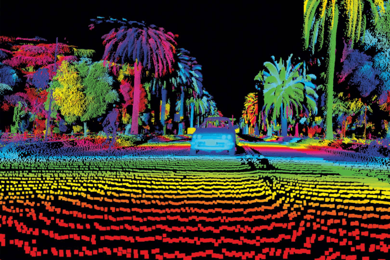
Lidar works by emitting laser pulses from a sensor and measuring the time it takes for each pulse to reflect off a surface and return to the sensor. This time-of-flight measurement allows the sensor to calculate the precise distance between itself and the object it encounters. By emitting thousands or even millions of laser pulses per second, Lidar sensors create highly detailed 3D point clouds that map the shape, depth, and texture of the environment.
A typical Lidar system consists of:
- A laser emitter to send out the pulses
- A sensor to receive the reflected signals
- A GPS unit for positioning data
- Inertial measurement units (IMU) to help with positioning and movement data
These components work together to produce a comprehensive and accurate 3D representation of physical environments.
Applications of Lidar in Various Industries
The flexibility and precision of Lidar make it invaluable across numerous industries. Below are some fields that leverage Lidar technology:
- Environmental Science: Lidar helps in mapping forest canopies, identifying terrain changes, and tracking natural habitats. It’s frequently used to study ecosystems and observe changes in topography due to erosion or climate change.
- Urban Planning: Cities use Lidar to create accurate models of urban areas, aiding in infrastructure planning, zoning, and construction. Lidar can map entire city blocks, providing detailed data to planners and developers.
- Autonomous Vehicles: Lidar acts as the “eyes” for autonomous vehicles, helping them navigate and avoid obstacles. By scanning the surroundings in real-time, Lidar provides precise data that informs the vehicle’s path.
- Archaeology: Archaeologists use Lidar to discover ancient structures hidden by dense vegetation. It’s particularly valuable in dense forests where traditional methods are challenging.
Lidar’s primary strength lies in its ability to generate detailed, accurate point clouds that provide precise measurements of both small and large areas. Its growing use and application in various industries highlight its potential to integrate seamlessly with photogrammetry for enhanced mapping capabilities.
![[webinar] drone photogrammetry vs. lidar wingtra [webinar] drone photogrammetry vs. lidar wingtra](https://wingtra.com/wp-content/uploads/webinar-lidar-vs-photogrammatry2.jpg)
Definition and Principles of Photogrammetry
Photogrammetry is the science of making measurements from photographs, typically to create 3D models, maps, or other visual data representations. Unlike Lidar, which relies on laser pulses to capture distance and depth, photogrammetry utilizes high-resolution imagery taken from various perspectives to produce accurate spatial data. Through this method, detailed models can be created by analyzing overlapping images and using mathematical calculations to determine the exact positions and shapes of objects within those images.
How Photogrammetry Works
Photogrammetry captures images of a physical object or area from multiple angles. Specialized software then uses algorithms to align the images based on common points visible across different views. This process, known as “image matching,” helps reconstruct 3D models by layering and processing the overlapping images. The steps generally include:
- Capturing multiple overlapping images from different perspectives
- Applying mathematical calculations to determine the position and orientation of each image
- Generating a 3D model by stitching the images together to represent surface details and features accurately
In many ways, photogrammetry relies on geometry and trigonometry to recreate a visual and dimensional representation of an area. While effective, photogrammetry can be labor-intensive and requires high-quality, clear images to maintain accuracy.
Core Differences Between Lidar and Photogrammetry
Although both Lidar and photogrammetry are widely used in mapping and surveying, they differ significantly in how they capture and interpret data. Below is a comparison of the two technologies based on key criteria:
| Criteria | Lidar | Photogrammetry |
|---|---|---|
| Data Capture | Laser pulses measuring distance | High-resolution images |
| Output Data | 3D point clouds | 3D models or 2D maps |
| Strengths | Accuracy in topography and terrain details | Rich color and texture information |
| Limitations | High cost; lacks color/texture | Dependent on light/weather conditions |
| Applications | Terrain mapping, forestry, autonomous cars | Architecture, real estate, archaeology |
Advantages and Disadvantages of Each
- Lidar excels in capturing elevation and depth, particularly for terrain mapping and forestry, where dense vegetation might obstruct visual access. However, it doesn’t capture color or surface textures as photogrammetry does, making it limited in applications requiring detailed surface visualization.
- Photogrammetry is ideal for architectural modeling and 3D reconstruction that requires color and texture data, making it popular in fields like real estate and archaeology. However, it struggles in low light or adverse weather conditions and may not be as accurate in measuring distances as Lidar.
These differences make it clear that while both methods are powerful on their own, their combination can offer a more comprehensive mapping solution by compensating for each other’s limitations.

Common Uses of Lidar in Photogrammetry Applications
While Lidar and photogrammetry are distinct technologies, they are increasingly used together to enhance mapping and 3D modeling accuracy. In applications where precision, texture, and structural data are needed, Lidar and photogrammetry complement each other effectively.
One of the most common uses of Lidar in photogrammetry is in aerial surveying. Drones or aircraft equipped with both Lidar sensors and high-resolution cameras can capture large areas quickly, combining Lidar’s depth data with photogrammetry’s visual details. This integration allows surveyors to generate comprehensive 3D models that are both dimensionally accurate and rich in detail.
Examples of Lidar in Photogrammetry:
- Topographic Mapping: Lidar provides precise elevation data, which photogrammetry enhances with visual details, making it ideal for creating detailed topographic maps.
- Forestry and Vegetation Analysis: Lidar penetrates dense canopies to measure tree heights and forest density, while photogrammetry captures the color and texture of the foliage. This combination helps in tracking changes in vegetation over time.
- Urban Planning and Development: Cities use combined Lidar-photogrammetry models to plan infrastructure, evaluate building heights, and assess potential construction impacts with high accuracy.
- Archaeological Sites: For delicate sites where contactless mapping is essential, Lidar scans the terrain to reveal buried structures, while photogrammetry helps reconstruct surface details, preserving historical accuracy.
How Lidar and Photogrammetry Work Together
When Lidar and photogrammetry are combined, they create a hybrid workflow that optimizes the strengths of both technologies. Here’s how the process generally works:
- Data Collection: Drones, aircraft, or ground-based systems equipped with both Lidar sensors and cameras capture data in a synchronized manner. For instance, Lidar might capture the terrain’s elevation while the camera captures images from multiple angles to provide color and texture.
- Data Processing and Integration: Once the data is collected, specialized software such as Pix4D or Agisoft Metashape processes the Lidar point cloud data and photogrammetric images. Using common points from both data sets, the software aligns them to produce a single 3D model with high dimensional accuracy and visual realism.
- Model Creation and Visualization: The combined data provides an enriched 3D model, ideal for visualizations and detailed analysis. This model typically includes both topographical accuracy and color detail, making it suitable for applications requiring precise measurements and visual clarity.
Case Study: Lidar and Photogrammetry in Disaster Management
In disaster-prone areas, integrating Lidar with photogrammetry enables rapid and detailed assessments post-event. For example, after an earthquake, surveyors can use Lidar to map changes in the terrain, while photogrammetry provides visual context to aid in understanding the damage. This combined data allows for more effective and responsive disaster management planning.
By using both Lidar and photogrammetry, industries can achieve high-quality, multi-dimensional models that provide both measurement precision and visual depth. This integration is particularly valuable in fields where detail and accuracy are paramount, such as urban development, forestry, and environmental conservation.

Advantages of Using Lidar in Photogrammetry
Enhanced Data Accuracy and Precision
One of the primary reasons to incorporate Lidar into photogrammetry is the unparalleled accuracy and precision it brings to data collection. Lidar captures millions of data points in real time, generating dense 3D point clouds that offer detailed insights into surface elevations, contours, and other physical features. When this precision is layered with photogrammetry’s high-resolution imagery, the result is a 3D model that is both dimensionally accurate and visually rich.
For instance, when mapping rugged terrains or densely forested areas, Lidar can penetrate tree canopies to accurately capture ground elevations—something photogrammetry alone might struggle with. This makes the combination particularly valuable for topographic mapping where detailed ground elevation data is critical.
Key Benefits of Lidar’s Precision:
- Sub-millimeter accuracy: Ideal for applications that require exact measurements, such as engineering and construction.
- Minimal distortion: Lidar’s laser pulses provide consistent results without the distortion sometimes seen in aerial photographs, making it more reliable for mapping varying terrain heights.
- Highly detailed point clouds: Lidar captures dense point clouds that can differentiate between subtle variations in topography, adding another layer of depth to photogrammetric models.
Improved Mapping Efficiency
Integrating Lidar with photogrammetry also significantly improves mapping efficiency. While photogrammetry can provide comprehensive visual data, it often requires optimal lighting, clear weather conditions, and slower processing times due to its reliance on high-quality imagery. In contrast, Lidar operates independently of lighting conditions and can scan large areas quickly, which is invaluable for large-scale mapping projects.
For example, Lidar-equipped drones can cover expansive areas much faster than traditional photogrammetry, gathering data even in overcast conditions or at night. This efficiency can reduce project timeframes and allow surveyors to conduct rapid scans, which is especially useful for time-sensitive projects like disaster response or infrastructure monitoring.
Efficiency Benefits of Lidar in Photogrammetry:
- Weather independence: Since Lidar doesn’t rely on sunlight, it can operate in challenging weather conditions, including cloudy or overcast skies.
- Speed of data collection: Lidar-enabled devices scan faster, making them suitable for large terrain surveys and time-sensitive applications.
- Reduced field time: Integrating both technologies can minimize the need for repeat site visits, saving both time and resources.
Increased Detail and Versatility in 3D Models
Using Lidar in photogrammetry offers a unique advantage in terms of detail and versatility. Lidar captures fine elevation details, while photogrammetry provides color and texture information, creating a more lifelike and comprehensive 3D model. This combination enables industries to achieve a level of detail that neither technology can provide on its own.
Consider architectural preservation projects, where both structural accuracy and surface texture are essential. Lidar captures the dimensions and shape of a building or monument with high precision, while photogrammetry adds the textures and colors that are crucial for a realistic representation. This dual approach is also valuable in fields like forestry, where the ability to measure and analyze both tree heights and canopy density is essential.
Applications Benefiting from High Detail and Versatility:
- Construction and Infrastructure: Lidar-photogrammetry models provide detailed insights into site layouts, enabling more effective project planning and progress tracking.
- Environmental Monitoring: Combined Lidar and photogrammetry are used to analyze landscape changes, such as erosion or vegetation growth, with both surface texture and topographic detail.
- Historical and Archaeological Mapping: Preserving both the form and aesthetic details of heritage sites, which helps in creating accurate, lifelike reconstructions for study and conservation.
By enhancing data detail and offering greater model versatility, the integration of Lidar in photogrammetry enables more nuanced analysis, making it highly beneficial for projects where both precision and visual depth are critical.